Collection Spotlight: Custom Display and Search Results inside PolicyMap

by John A. Olson, Librarian for Government and Geo-Information
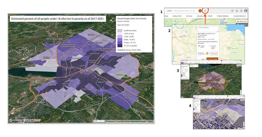
Need a custom map depicting specific census related data and a geographic area for your research paper or presentation? PolicyMap, a database found in the libraries’ database menu, might be just what you’re looking for. Within PolicyMap there is a feature called Custom Regions and it gives you the ability to create three different types of custom geographic boundary areas. One of those is the Radius Region, and this is how it works:
- To start, click on the Custom Regions icon tool next to the search box.
- Select the Create Region then click the Radius Region radio button and hit continue. Zoom into the area you want to map. Now take your mouse curser, which has turned into a “+” sign, and click on a specific place on the map. You can then specify the radius in miles. Hit continue and then give your location map a name.
- Now go through the process of selecting a data variable from the menu across the top. Once you have picked the variable and it is displayed on your map, click the SCISSORS icon at the bottom to cut out the mapped data layer. Click on the GEAR WHEEL “Base Map Settings” to the right of the scissors and select the Satellite layer. Now click the 3D and COMPASS buttons to give your map a 3-D effect and/or to rotate it for a different perspective.
- Click the PRINT button in the lower right corner, save your file as either a PDF or as a PNG file and then hit EXPORT. Check your computer’s download folder for your file. It will take a few minutes, so be patient. Or you can share with others by creating a link, emailing it, as an embedded object or on social media. You can also generate and download a report, or the data table for that custom region.
Here’s another cool feature: if you now switch your base map to Terrain, you can then zoom in to a specific area that will show 3D building on your map.
To provide feedback or suggest a title to add to the collection, please complete the Resource Feedback Form
